Environmental Intelligence for Upstream Energy
Protect Critical Assets. Simplify Compliance. Reduce Environmental Risk.

SiteCrest gives upstream operators complete visibility and control over environmental obligations—from historical assessments through ongoing operations to final regulatory closure. Replace fragmented documents, disconnected processes, and manual tracking with one intelligent platform designed around real regulatory workflows.
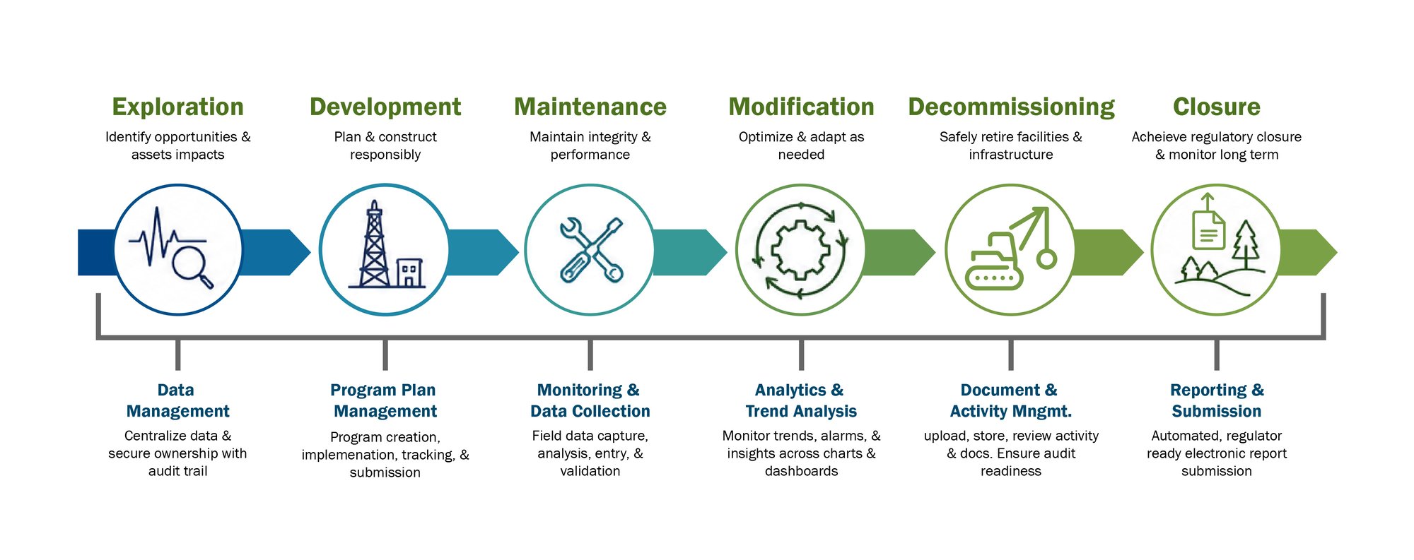
Why Upstream Producers Choose SiteCrest
Maintain Complete Visibility and Control
Environmental information is a critical business asset that should remain accessible, consistent, and readily available throughout the asset lifecycle.
SiteCrest brings assessments, monitoring programs, environmental activities, and regulatory submissions together in a single system of record, providing a trusted foundation for collaboration, governance, and decision-making.
Deliver Cost Certainty & Accelerate Closure
Improve project efficiency while increasing confidence in environmental outcomes.
Standardized, jurisdiction-specific workflows help streamline environmental programs, reduce administrative effort, and improve predictability from assessment through closure and divestment.
Outcomes
-
Improved project predictability
-
Faster project completion
-
Reduced administrative burden
-
Greater confidence in closure outcomes
-
More effective use of environmental resources
-
Strengthen Compliance and Risk Management
Reduce Compliance & Regulatory Risk
Gain a clear understanding of environmental commitments, program status, and emerging risks across your portfolio.
Comprehensive audit trails, approval workflows, and centralized oversight provide transparency and accountability while supporting regulatory compliance and corporate governance objectives.
Benefits
-
Continuous compliance visibility
-
Audit-ready documentation
-
Enhanced risk awareness
-
Stronger governance and accountability
-
Improved regulatory confidence
-
Enable Better Business Decisions
Turn environmental information into actionable intelligence
Through centralized data management, performance dashboards, and portfolio-level analytics, SiteCrest helps organizations understand environmental performance, prioritize investments, support transactions, and make informed operational and strategic decisions with confidence
Operational Efficiency - Tangible Benefits
Move Beyond Static Reports
SiteCrest provides real-time visibility into site progress, outstanding activities and milestones while preserving owner control over environmental strategy
Improve Compliance
Keep environmental programs aligned with regulatory obligations and operational commitments. Keep environmental programs aligned with regulatory obligations and operational commitments
Source of Truth
SiteCrest maintains a permanent digital history of every activity, approval, decision, and assessment — preserving institutional knowledge even when personnel changes.
Platform Capabilities
Criteria:
- Tabled Values
- Site-Specific Criteria
- Guideline Modification/Recalculations
Table Criteria:
- Alberta (Soil, Groundwater, Surface Water, Sediment)
- Saskatchewan (Soil, Groundwater, Surface Water)
- British Columbia (Soil, Groundwater, Surface Water, Vapour)
- Ontario (Soil, Groundwater, Sediment)
- Federal (Soil, Groundwater, Surface Water)
Environmental Analysis:
- Soil
- Groundwater
- Surface Water
- Vapour
- Sediment
Guideline Modification:
- AB and SK guideline modification
Visualizations:
- Aerial Map
- Lithology Plot
- 3D Plot
- Trend Analysis
- Simple X-Section
Analytics:
- Analytical Summary
- Impact Volume Estimate
- Trend Analysis
- COPC Screening Table
- Groundwater Contouring
Exports/Reports:
- GPS Coordinates, Water Levels, COPC Screening, Ksat (In-situ), Analytical Summary
- Basic Print Functions (Maps, BH Logs, 3D Plot)
- AB Tier 2 Guideline Modification Reports
Preconfigured exports are included in base function to align with routine reporting requirements. Additionally, the Tier 2 Guideline Modification Report is specifically designed for direct reporting within technical documentation to support regulatory submission for guidelines recalculation and modification workflows.
Data Persistence/Saving:
- Version Control
- Data Views/Collections
Designed to capture the conceptual site model and the business rules applied with respect to the compliance objectives.
Data persistence in SAT has been designed to capture and lock the analyzed data such that no manipulation of the underlying data or the criteria that is applied can be made.
Workflow Integration:
- Proposed Borehole inputs for site assessment planning
Capabilities suited for site management and site strategy planning to streamline communication and store critical site decisions for future retrieval on demand.
Key Benefits
Maintains visibility to current regulatory requirements, reduces rework when criteria change, and supports defensible, auditable compliance decisions across the portfolio.
Standardizes technical assessment methods, improves consistency across sites, accelerates review, and supports defensible governance for risk and remediation decisions through an approved conceptual site model.
Improves data quality and traceability, reduces manual reconciliation, supports audit readiness, and enables faster portfolio-level decisions from consistent source data.
Enables portfolio-level oversight, consistent site governance, faster prioritization, and cost avoidance through standardized assessments.
Turn 1-week tasks into 1-hour tasks
Key Performance Indictors:
- > 80% cost reduction in project handover within and between organization.
- > 80% cost reduction in data recast efforts when regulatory changes occurring.
- > 60% cost reduction in guideline recalculation.
- > 80% cost reduction in figures and cross-section generation.
Criteria/Default Values:
- AB Tier 1/2, SK SEQG, and SK DDR.
- Default physical/chemical parameters based on regulatory approved values
Table Criteria:
- Alberta Soil and Groundwater Remediation Guidelines 2024
- Saskatchewan Environmental Code, Discharge and Discovery Reporting Standard 2024
- Saskatchewan Environmental Quality Guidelines 2024
Analytics/Visualizations:
- Maximum Projected Plume Length
- Maximum Projected Concentration at “Clicked” location
- Map and Map Layers
- Center Line Concentration Profile
- Breakthrough Curve (BTC) at “Clicked Location
User Inputs/Analytics Adaptation:
- Media (Soil and Groundwater)
- Chemicals, Source Concentration
- Model Selection
- Source Depletion (Optional)
- Site-Specific Transport Parameters
Models:
- Partitioning
- Leaching
- Mixing
- Lateral transport: Domenico (CCME) – 2D
SiteCrest's Natural Attenuation Tool (NAT) uses the Domenico (1987) three-dimensional analytical solute transport model to compute the natural attenuation of chemicals in the saturated zone in combination with other dilution models to account for partitioning, leaching and groundwater mixing. These are the same models applied in the Canadian Council of Ministers of the Environment protocols for deriving soil (CCME, 2006) and groundwater (CCME, 2015) guidelines, the Canada-Wide Standard for Petroleum Hydrocarbons in Soil (CCME, 2008), the Alberta Environment and Protected Areas Tier 1 and Tier 2 groundwater guidelines (EPA, 2024a,b), and the United States Environmental Protection Agency BIOSCREEN Natural Attenuation Decision Support System (US EPA, 1996).
Exports/Reports:
- Autogenerated Report
- 2D aerial plots of plume
- Breakthrough Curve (BTC) Plots
- Centerline Plot
- Print Map
Reports are specifically designed for direct integration within technical documentation to support regulatory submission for risk-based evaluations of natural attenuation. Autogenerated reports include:
- Site-Specific Input Parameters
- Chemical specific input parameters
- User Defined Input parameters
- Model Assumptions
- Model Equations & Variable definitions
- Example calculation
Full print and save functions can be leveraged for embedding visuals in technical reports and presentations.
Data Persistence/Saving:
- Version Control
- Data Views/Collections
Designed to capture the conceptual site model and the business rules applied with respect to the compliance objectives. Data persistence in NAT has been designed to capture and lock the modelled data such that no manipulation of the underlying data or the criteria and input parameters that is applied can be made.
Workflow Integration:
- Proposed Borehole inputs for site assessment planning
Key Benefits
Regulatory & Site Management Advantages:
- Ensures regulatory compliance for contaminated site management.
- Provides a delineation alternative in cases where physical sampling is restricted.
- Supports site closure efforts by demonstrating attenuation trends.
Cost & Time Savings:
- Avoids delays in site remediation and redevelopment, preventing:
- Increased risks to sensitive receptors.
- Unnecessary expenses on repeated investigations and monitoring.
- Data obsolescence due to prolonged assessment cycles.
Reduced Regulatory & Legal Complexities:
- Minimizes the need for supplemental investigations, reducing legal and financial barriers to access agreements.
- Help avoid regulatory delays due to incomplete delineation.
Improved Health & Safety:
- Reduces exposure to hazardous environments associated with intrusive investigations.
- Lowers risk in highly sensitive off-site areas.
Environmental Protection:
- Minimizes site disturbances, preventing damage to existing ecosystems.
- Prevents unnecessary drilling that could disrupt groundwater flow or introduce new contaminants.
- Reduces environmental risk associated with vegetation remove and permafrost disruption, in ecologically sensitive areas.
Key Performance Indictors:
- Reduce delineation costs and accelerate projects for sites where plume dynamics are well understood.
Reduce or eliminate the need for costly supplemental drilling using NAT as an alternative delineation method.
Site Creation and Management:
- Add and manage highlight level details for sites
Documentation of sites within a portfolio capturing site locations, project numbers, client site identification, descriptions, etc. all integrated into a map visualization interface.
Data Import/Storage:
- Interactive and customizable geospatial inputs Single Data Entry (SDE)/ batch uploads from Electronic Data Deliverables (EDDs)
- Document attachments to geospatial features
- Data Service Layers
- Full Create, Read, Update, Delete (CRUD) functionality
- Scalable cloud storage.
Batch data uploads via simple data templates supports faster ingress of geospatial, analytical and field data. Integrated light weight map layer ingress options allow for easy access to public service layers, georeferenced image rendering, and shapefiles uploads. Tagging of attachments to geospatial points, line, and polygons enables quick access to unstructured data sources. Full export functions to quickly get data out of the system to enable integration with other software systems and analysis tools.
Data Export:
- Bulk data exports for transfer and edits.
Quality Checks:
- Pre-upload data format validation
- Post-upload data flags for completeness and integrity
Project Tracking:
- Site project creation and tracking
- Tagging Projects to geospatial and analytical imports
Key Benefits
Centralized data governance provides complete corporate control over the environmental data that is collected and managed on behalf of the organization.
Complete data control enables data access on demand and cuts costs from inefficient data handovers and knowledge silos.
Enable teams to work more efficiently and effectively by providing greater data visibility to multiple parts of the organization who would benefit from accessing a secure repository of corporate environmental data.
Eliminate data silos and enable effective knowledge transfers between teams that will result in cost savings and better environmental management throughput, internally and externally.
Key Performance Indictors:
- > 80% cost reduction in project handover within and between organization.
- < 1 min to give site data access to a 3rd party vendor to millions of data points.
Manage Environmental and Commercial Information:
- Add and track key environmental and commercial objectives for data transparency enabling portfolio roll-up analysis and obligation awareness.
Site & Activity Tracking:
- Target Dates and key deliverables
- Consultants and Related Project Managers (Internal and External)
- Priority
- End Land Use Objectives
- Multiple Activity Types supporting full spectrum of industries and service areas
- Key Performance Indicator (KPI) tracking for spending based on baseline and alternative methodologies to environmental management strategies, activity completion deliverables, and portfolio level visibility on performance.
Portfolio Oversight
- Site compilation in grid format for high-level portfolio overview with ability to group and filter for specific track information.
- Portfolio can be exported for external business intelligence.
Activity and Cost Tracking
- Add and track activities and obligations for a site.
- Add, track, and compare cost of activities for a site.
Document Attachments
- Upload documents associated with activities to capture unstructured data.
Upload reports and relevant documentation to an activity for tracking and storage. Files can be downloaded for review. Ideal for field notes, unstructured observational data, photos, safety tickets, report repository.
Activity Alerts
- In-app 30-day alert when activities are actioned and not completed.
Site Summary (Environmental)
- View collections of site summary information.
Summary of site conditions that reflect the most recent record of the site in terms of environmental impacts (if any), conclusions, recommendations, and next steps. Keep clear line of sight into next planned activity while still being able to scan through previous summaries to paint a picture of the site progression.
Key Benefits
Provides portfolio visibility into obligations, priorities, target dates, responsible parties, and land-use objectives for faster risk-based decisions.
Improves accountability by linking activities to owners, dates, priorities, deliverables, and consultants.
Supports cost control through KPI tracking of spend, activity completion, and management strategy performance.
Preserves corporate knowledge by attaching reports, field notes, photos, safety tickets, and observational records to activities.
Improves handover continuity with current site conditions, conclusions, recommendations, next steps, and site history.
Increase accountability, protect corporate knowledge, and improve portfolio decisions.
Key Performance Indictors:
- > 80% cost reduction in project handover within and between organization.
- > 70% reduction in project delays between internal stakeholders and an acceleration in achieving site level environmental and corporate objectives.
Digital Reporting:
- Views serve as permanent digital reports and artifacts of analyzed information.
- Compilation of digital reports across activities per site.
Data views contain all information rendered and persisted on Site Assessment Tool, including, but not limited to, marked geospatial features, conceptual site model, filters visualization settings, criteria analysis, groundwater contouring, cross-section markings, data layers, etc. Views can be grouped into folders for digital file management per site.
View Renderer:
- Quick access and viewing digital reports available per site.
Visualizations:
- Aerial Map
- Lithology Plot
- 3D Plot
- Trend Analysis
- Simple X-Section
Analytics:
- Analytical Summary
- Impact Volume Estimate
- Trend Analysis
- COPC Screening Table
- Groundwater Contouring
On-demand analytics and exports are available for persisted data for review, professional judgement and external demonstrations. Preconfigured exports are included in base function to align with routine reporting requirements.
Additionally, the Tier 2 Guideline Modification Report is specifically designed for direct reporting within technical documentation to support regulatory submission for guidelines recalculation and modification workflows.
Exports/Reports:
- GPS Coordinates, Water Levels, COPC Screening, Ksat (In-situ), Analytical Summary
- Basic Print Functions (Maps, BH Logs, 3D Plot)
- AB Tier 2 Guideline Modification Reports
Key Benefits
Standardizes technical assessment methods, improves consistency across sites, accelerates review, and supports defensible governance for risk and remediation decisions.
Locking in an agreed upon conceptual site model reduces errors and misalignment in site management strategy during portfolio handover. Retaining knowledge of the site management strategies and historical environmental events during operations through to end-of-life reducing corporate risk of knowledge loss over longer project timelines.
Keeping corporate environmental knowledge safe and secure saves money and time.
Key Performance Indictors:
- > 80% cost reduction in project handover within and between organization.
- > 90% cost reduction in annual groundwater reporting by switching to digital reports.
In-app/Email Notifications
Set notifications for specific actions at the client or site-level delivered in-app and/or by daily email delivery.
Notifications supported for:
- Site creation
- Data upload/update/deletions
- Site summary notification for accepted assessment
- Activity status updates
- Site tracking information updates
Notifications stored in a message center for review. User can set notifications for the desired client or sites (where applicable).
Manage Users
- Add, update or remove a user from your own company and provide broad site access.
Manage Site Access to Users
- Enable, update, or remove access of users belonging to the same company to specific sites.
- Automated permission roll-forward available for newly added sites to reduce manual administrative load.
Tiered access is available per module (SAT and Data Management) ranging from read-only to full module capability. Managed by one or more users within the company designated as Administrator.
Manage External Parties/Companies
- Add, update, or remove a partnership with an external party/company for site sharing.
Manage Site Access to External Parties/ Companies
- Enable, update, or remove external parties/companies access to specific sites.
- Sharing of sites with multiple parties
Partnerships between organizations enable data sharing to occur at the individual site level. When a site is shared with an external party, all users under that party may get access to the site via the automated permission roll-forward.
Key Benefits
Stay informed on how system contributors are updating site data to achieve their deliverables, creating and managing sites on behalf of the organization, when assessment work has an accepted CSM, and when site activity status changes.
-
Strengthens governance through controlled user, company, site, and module-level access.
-
Reduces administrative effort with automated permission roll-forward for newly added sites.
-
Enables secure collaboration with vendors, partners, and external users while limiting access to approved sites.
-
Improves accountability by aligning access rights with roles, organizations, and site responsibilities.
Control access, reduce admin effort, and collaborate securely across organizations.
Key Performance Indictors:
- < 1 min to share data with 3rd party.
- > 80% cost reduction in project handover within and between organization.