Cost-Efficient, Advanced Predictive Modeling
Reduce remediation costs while minimizing environmental impact
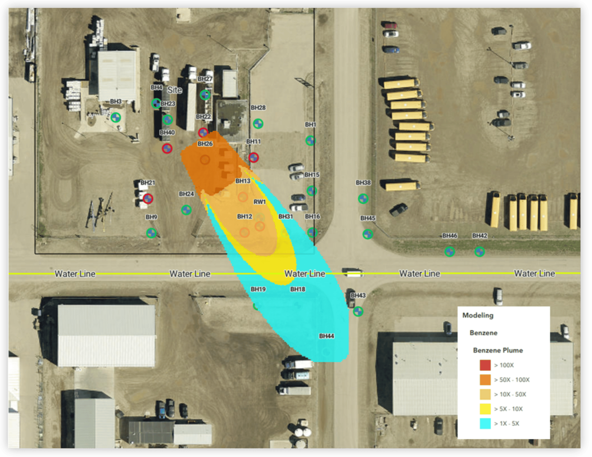
Enable risk modeling for nearby receptors while optimizing delineation strategies that minimize environmental impact and remediation costs.
Key Features
Criteria/Default Values:
- AB Tier 1/2, SK SEQG, and SK DDR.
- Default physical/chemical parameters based on regulatory approved values
Table Criteria:
- Alberta Soil and Groundwater Remediation Guidelines 2024
- Saskatchewan Environmental Code, Discharge and Discovery Reporting Standard 2024
- Saskatchewan Environmental Quality Guidelines 2024
Analytics/Visualizations:
- Maximum Projected Plume Length
- Maximum Projected Concentration at “Clicked” location
- Map and Map Layers
- Center Line Concentration Profile
- Breakthrough Curve (BTC) at “Clicked Location
User Inputs/Analytics Adaptation:
- Media (Soil and Groundwater)
- Chemicals, Source Concentration
- Model Selection
- Source Depletion (Optional)
- Site-Specific Transport Parameters
Models:
- Partitioning
- Leaching
- Mixing
- Lateral transport: Domenico (CCME) – 2D
SiteCrest's Natural Attenuation Tool (NAT) uses the Domenico (1987) three-dimensional analytical solute transport model to compute the natural attenuation of chemicals in the saturated zone in combination with other dilution models to account for partitioning, leaching and groundwater mixing. These are the same models applied in the Canadian Council of Ministers of the Environment protocols for deriving soil (CCME, 2006) and groundwater (CCME, 2015) guidelines, the Canada-Wide Standard for Petroleum Hydrocarbons in Soil (CCME, 2008), the Alberta Environment and Protected Areas Tier 1 and Tier 2 groundwater guidelines (EPA, 2024a,b), and the United States Environmental Protection Agency BIOSCREEN Natural Attenuation Decision Support System (US EPA, 1996).
Exports/Reports:
- Autogenerated Report
- 2D aerial plots of plume
- Breakthrough Curve (BTC) Plots
- Centerline Plot
- Print Map
Reports are specifically designed for direct integration within technical documentation to support regulatory submission for risk-based evaluations of natural attenuation. Autogenerated reports include:
- Site-Specific Input Parameters
- Chemical specific input parameters
- User Defined Input parameters
- Model Assumptions
- Model Equations & Variable definitions
- Example calculation
Full print and save functions can be leveraged for embedding visuals in technical reports and presentations.
Data Persistence/Saving:
- Version Control
- Data Views/Collections
Designed to capture the conceptual site model and the business rules applied with respect to the compliance objectives. Data persistence in NAT has been designed to capture and lock the modelled data such that no manipulation of the underlying data or the criteria and input parameters that is applied can be made.
Workflow Integration:
- Proposed Borehole inputs for site assessment planning
Key Benefits
Regulatory & Site Management Advantages:
- Ensures regulatory compliance for contaminated site management.
- Provides a delineation alternative in cases where physical sampling is restricted.
- Supports site closure efforts by demonstrating attenuation trends.
Cost & Time Savings:
- Avoids delays in site remediation and redevelopment, preventing:
- Increased risks to sensitive receptors.
- Unnecessary expenses on repeated investigations and monitoring.
- Data obsolescence due to prolonged assessment cycles.
Reduced Regulatory & Legal Complexities:
- Minimizes the need for supplemental investigations, reducing legal and financial barriers to access agreements.
- Help avoid regulatory delays due to incomplete delineation.
Improved Health & Safety:
- Reduces exposure to hazardous environments associated with intrusive investigations.
- Lowers risk in highly sensitive off-site areas.
Environmental Protection:
- Minimizes site disturbances, preventing damage to existing ecosystems.
- Prevents unnecessary drilling that could disrupt groundwater flow or introduce new contaminants.
- Reduces environmental risk associated with vegetation remove and permafrost disruption, in ecologically sensitive areas.
Key Performance Indictors:
- Reduce delineation costs and accelerate projects for sites where plume dynamics are well understood.
Reduce or eliminate the need for costly supplemental drilling using NAT as an alternative delineation method.